Photogrammetry software: what it does, the kinds, and free options
What photogrammetry software does between the photos and the model, the kinds there are, the free open-source programs, and the files and checks that matter before you pick one.
Published · 9 min read · By Malya, the makers of Clarity
Photogrammetry software is the part of the method that looks like magic from outside and is mostly arithmetic from inside. This page says what it does between the photographs and the model, sorts the kinds of software there are, names the free open-source programs, and lists what to check before choosing one, because the differences that matter are rarely the ones on the feature list.
What happens inside
Every photogrammetry program, whatever it calls the steps, runs the same chain. The how it works page shows each step on real pictures; here is what the software is doing at each, and what the settings it exposes actually control.
- Feature detection and matching
- Finds distinctive patches in every photograph and matches them between pictures. The 'quality' or 'accuracy' setting usually decides how much of each photograph is used: full resolution is slower and finds more.
- Alignment (bundle adjustment)
- Solves every camera's position and orientation, the lens model and the tie points together. Camera positions from GNSS and ground control enter here; the report's reprojection error comes out of it.
- Dense matching
- Finds depth at nearly every pixel. The slowest step by far, and the one the quality setting most affects. Produces the dense point cloud.
- Products
- Mesh from the cloud, orthomosaic from the photographs projected on the surface, DSM and DTM sampled from it, contours from the DTM. Each with its own resolution setting.
The kinds of software
- Desktop processingRuns the whole pipeline on your own computer. Full control over every setting, no per-project fee, works offline. Needs a serious workstation and hours of its time; the result is files on a disk.licence · your hardware
- Cloud processingUpload the photographs; a server sized for the job runs the pipeline and returns the products, usually into a viewer. No workstation, no waiting at a desk, and the results are already shared.per project or subscription
- Open source and research toolsFree processing engines and the libraries underneath them. Capable and well understood; you supply the hardware, the setup, and the knowledge to drive them. The right choice for learning what the settings do.free · your time
- Viewers and measuring platformsWhere the model is used: measured, compared between dates, annotated, exported and shared with people who never ran the processing. Some processors include one; some platforms accept files from any processor.subscription
The split that matters for a site crew is the last one. The processing is run once per flight; the measuring is done every day for months by people who should never have to open a processing program.
Free and open-source photogrammetry software
Three free programs cover most of what people mean by free photogrammetry software. All three are open source and run on a computer you provide.
- OpenDroneMap
- An open-source toolkit made for aerial photographs. It produces the orthomosaic, the surface and terrain models, the point cloud and a textured mesh; WebODM is its interface in a web browser. The usual free choice for drone mapping.
- Meshroom
- An open-source program from the AliceVision project that lays the pipeline out as connected steps you can open and change. Aimed at 3D models of objects and scenes rather than maps; available for Windows and Linux.
- COLMAP
- An open-source structure-from-motion and multi-view stereo pipeline, with a graphical interface and a command line, under the BSD licence. A common starting point in research and for people who want to see each step.
What they leave to you is the computer, the setup and the judgement to drive them, and what they hand back is files rather than a place to measure and share them. The guide to free drone mapping software covers the rest of the free route, including free viewers and GIS.
After processing: where the model is used
A processed survey is three or four large files that most of the people who need its answers cannot open. The point of a measuring platform is to put those files in a browser, with the tools to read a volume, a grade, a contour or a cut and fill off them, the method printed beside each number, and a link to send the result to whoever has to sign it.
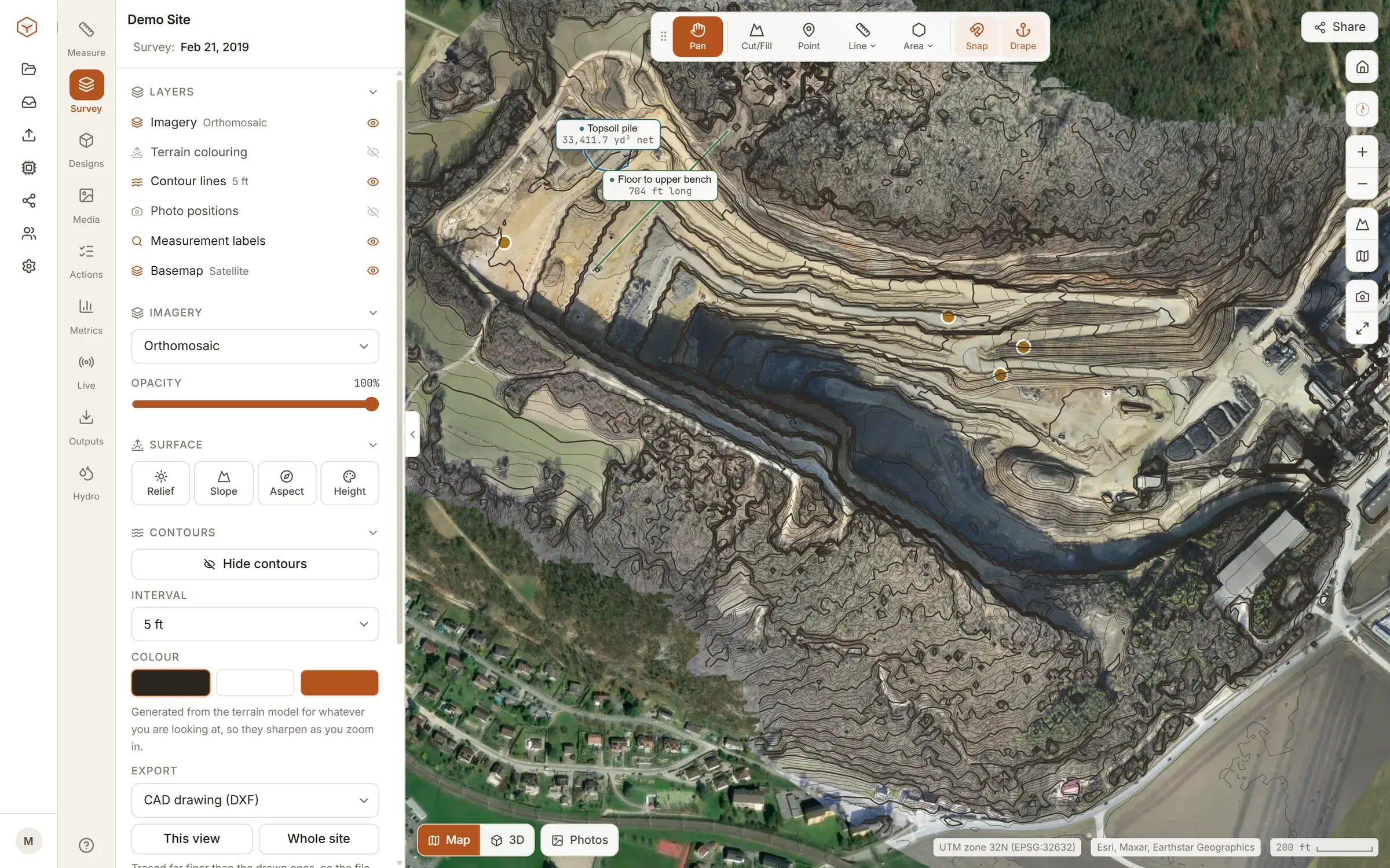
Clarity is that platform: it opens the orthomosaic, DSM and DTM from any processor on the Studio plan, and on Enterprise it runs the processing from the photographs too. The guide to choosing drone survey software is the buyer’s version of this page.
What to check before choosing
| Ask | Why it matters | |
|---|---|---|
| Does it export GeoTIFF, LAS/LAZ, and DXF or LandXML, in my coordinate system? | If not, the model is locked inside the product and the next tool in the chain cannot use it | |
| Does it support ground control points and RTK/PPK photo positions, and report residuals on both? | Absolute accuracy depends on it, and the report is how you know the accuracy you got | |
| Can it hold check points out of the solution and report their error? | The only honest accuracy figure. Software that fits every point you give it cannot tell you how good it is | |
| Does it model rolling shutter, and can it use a fixed camera calibration? | The two camera errors that no amount of control removes | |
| Where does the processing run, and how long does a thousand photographs take? | A desktop product is a workstation purchase; a cloud product is a wait you do not have to watch | |
| Where is the model used afterwards, and by whom? | Most of the value of a survey is in the measuring, which the whole crew does and the processor does not | |
| Can the people who need the number open it without a licence or training? | A model nobody can open answers no questions |
The files, and why they matter
The products
- Orthomosaic: GeoTIFF, often Cloud-Optimised (COG) for the web
- DSM and DTM: GeoTIFF, one band of heights
- Point cloud: LAS, or LAZ compressed, with colour and classification
- Mesh: OBJ with textures, or glTF/GLB for the web
- Linework: DXF or LandXML for contours, breaklines, surfaces
What to insist on
- A named coordinate system (EPSG code) on every file, matching the control
- The processing report with reprojection error, control residuals and check-point RMSE
- The camera positions and orientations, so the survey can be reprocessed later
- The original photographs kept with the survey; they answer questions the model cannot
The three-files guide says what each product holds and which to measure on; the glossary has every term used above.
Questions people ask
What does photogrammetry software actually do?
It finds features in every photograph, matches them between photographs, solves where every camera was and the lens's geometry in one calculation, builds a dense point cloud, joins it into a mesh, and produces an orthomosaic and elevation models in real-world coordinates, with a report of how well it all fitted.
Is there free photogrammetry software?
Yes. OpenDroneMap (with its WebODM interface), Meshroom and COLMAP are free and open source and run the full pipeline on your own computer, and several commercial products have free tiers. Free software gives you the files; what it does not give you is a workstation sized for thousands of photographs, support, or a place to measure and share the result.
Do I need a powerful computer?
For desktop processing, yes: a modern multi-core processor, 32–64 GB of memory and a capable graphics card for a few thousand photographs, and patience. Cloud processing moves that to a server, so the computer you need is whatever opens a browser.
What file formats should photogrammetry software produce?
GeoTIFF for the orthomosaic and elevation models, LAS or LAZ for the point cloud, OBJ or glTF for the mesh, and DXF or LandXML for contours and linework, all in a named coordinate system (an EPSG code). If a product cannot export these, the model is stuck inside it.
What is the difference between processing software and a viewer?
Processing turns photographs into the model; a viewer or platform is where the model is measured, compared and shared afterwards. Some products do both, some only one. Clarity is a viewer and measuring platform that also processes photographs on the Enterprise plan, and accepts files processed anywhere else.
See it on a real site.
Explore is free, with no card and no expiry: a real quarry, already flown and processed, with every measuring tool on it.
Read next
- Photogrammetry equipment: everything you need, from phone to droneThe kit, from a phone and a scale bar to an RTK drone and a scanning robot, and what each buys you.
- LiDAR vs photogrammetry: which is better for a survey?Laser against camera: what each sees through trees, what each costs, and the cases where one wins outright.
- Photogrammetry vs 3D scanning for creating a 3D modelCamera or scanner for a 3D model: range, accuracy, speed and colour, side by side.
- All resources