Robot dogs and ground robots for site scanning and progress capture
Quadruped robots and rovers that walk a site on a schedule carrying a laser scanner or a 360 camera: what they capture, how the data is used against the model, what they cost and where they fit beside drones.
Published · 8 min read · By Malya, the makers of Clarity
A robot dog on a building site is not a novelty act; it is a tripod that walks. The hard part of scanning a building under construction was never the scanner, it was carrying it to two hundred stations every week and setting it down in the same places. A quadruped does that on its own, and the data it brings back is the first kind of site record that is the same every time it is taken.
What they are
A ground robot for capture is a self-navigating carrier with a sensor on top: a four-legged quadruped for stairs, rubble and door thresholds, or a wheeled or tracked rover for flat slabs and yards. The robot looks after walking and not falling; the payload (a laser scanner, a 360° camera, sometimes both) looks after measuring. In 2020 the scanner makers began shipping the two as one product, with the robot carrying a survey-grade scanner and the scanner’s software driving the robot from station to station, and the combination has since gone into regular use on large projects.
- 1,000+
- Quadrupeds of one make reported in the field by 2021, many on construction sites
- ~$74,500
- A reported price for a quadruped with a survey scanner on its back
- weekly
- The usual rhythm: the same route, the same stations, every week
- 0 GNSS
- Satellites needed indoors. The robot positions itself from what it sees
The route, the stations, the schedule
The animation at the top is the whole method. Somebody walks the robot through the floor once, with the controller, and it records the route and the places where it should stop. From then on it repeats the mission on its own: walks to station one, stands still, scans, walks to station two. If a pallet has appeared on the route it steps round it; if a wall has gone up it finds another way or reports that it cannot. The scans from each visit are taken from the same places, so the comparison between weeks is a subtraction rather than a search.
Once
Record the route
A person drives the robot through the space; it maps as it goes and remembers the stations. Control points on the floor tie the map to project coordinates.
Each visit
Walk and scan
The robot repeats the mission on a schedule or on command, scanning at every station. An operator can watch remotely and does not need to be on the floor.
Same day
Register and compare
The scans are joined into one cloud in project coordinates and compared with the design model and with the previous visit.
Ongoing
Act on the differences
Elements built, elements missing, elements out of tolerance, each flagged for the people who need to know, with the scan as evidence.
Quadrupeds, rovers and the rest
- Quadruped (robot dog)Four legs: stairs, kerbs, rubble, thresholds, a floor with the deck still open. The usual choice inside a building under construction, where nothing is flat yet. Hours of battery; swaps its own.indoors and rough ground · $75,000–150,000 with scanner
- Wheeled or tracked roverCheaper, carries more, runs longer, and cannot climb a stair. Fine on finished slabs, in yards, along a pipe rack, through a warehouse. Some print layout on the slab as they go.flat ground · $20,000–80,000 with sensors
- The human alternativeA handheld SLAM scanner carried by a person on the same route, every week. Less repeatable, far cheaper, and the right answer on a site that is not large enough to keep a robot busy.anywhere · $20,000–60,000
What rides on the back
The robot is the legs; what it carries decides what the site gets.
- Terrestrial laser scanner
- Millimetres, colour, and a full dome at each station. The survey-grade option, and the heaviest and dearest. The scanner's own software plans the stations and registers the scans.
- Spinning LiDAR with SLAM
- A continuous cloud as the robot walks, centimetre-level, no stations needed. Faster and less precise; good enough for progress, not for as-built tolerance checks.
- 360° camera
- A walkthrough the whole team can open, with the images placed on the plan. Visual, not measured, unless the images are also run through photogrammetry.
- Thermal, gas, acoustic sensors
- Beyond geometry: heat on a panel, a leak, a running pump. The same route logic applies: measure the same places on every visit and compare.
What the data is used for
Three things, in order of how often they are done. Progress: what has been built since last week, by element, against the programme. Verification: what has been built where it should be, within tolerance, against the design model, caught while the trade is still on the floor. And the record: an as-built scan of every floor at every stage, for the handover and for the arguments afterwards. An architecture practice testing a quadruped on a London site in 2020 ran it weekly on the same pre-mapped missions and compared each visit with the BIM model and the programme, which is the same loop the scanner makers built their products around.
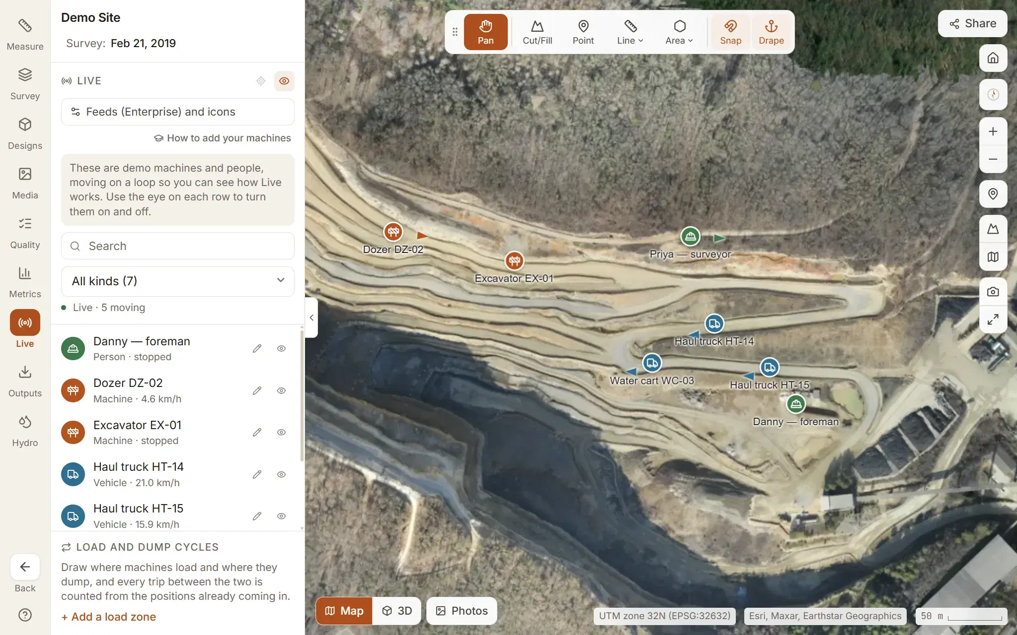
The robot’s own position is a product in its own right: where it is on the site, in real time, on the same map as the trucks and the excavators. Clarity’s live tracking shows anything that reports its position on the site map, and plays back where it went.
What they cost and when they pay
A quadruped with a survey scanner was reported at about $74,500 in 2021; the robot alone is in the tens of thousands, the scanner is the rest, and software, support and a spare battery or two come on top. Rovers with lighter sensors are a fraction of that. Against it: a scanning technician’s weekly visit to a large site for a year, with the stations never quite in the same place, or a site that goes unscanned because nobody has the time. The arithmetic works on a big project with many floors and a long programme, and does not on a small one, which is why the robots are on hospitals and data centres rather than houses.
| Pays off when | Does not when | |
|---|---|---|
| Site | Large, multi-storey, long programme; several floors in work at once | Small, short, or mostly open ground a drone covers in ten minutes |
| Capture | Weekly or daily, for months, from the same stations | A one-off scan, or a capture that changes route every time |
| Terrain | Stairs, thresholds, open decks: where a rover cannot go and a person would rather not | Finished floors a rover handles, or outdoor ground a drone sees from above |
| People | A team that will act on the differences the scans show | Scans nobody opens |
Robot against drone
The robot
- Goes inside: floors, basements, plant rooms, tunnels
- Carries a survey scanner: millimetres on walls and columns
- Repeats a route exactly, on a schedule, without a pilot
- Slow, and sees only what is in line of sight from its stations
The drone
- Covers the whole site from above in one flight
- Photogrammetry: colour, texture, the orthomosaic, volumes
- Cheap enough for the site crew to own and fly
- Cannot go indoors, and sees roofs rather than rooms
On a large project the answer is both, tied to the same control: the drone for the earthworks, the stockpiles, the structure rising and the site as a whole, the robot for what is happening inside it. The drones page covers the first; the scanners page explains what the second carries.
Sources
Questions people ask
What does a robot dog do on a construction site?
It walks a recorded route on a schedule carrying a laser scanner or a 360° camera, stops at the same stations each time, captures, and moves on. The scans are compared with the design model and with last week's scans to show what has been built, what is out of place and what is behind.
How much does a scanning robot dog cost?
The robot alone is in the tens of thousands of dollars; with a survey-grade laser scanner on its back a complete package was reported at about $74,500, and scanner, software and support can take it well past $100,000. It is a capital purchase that pays off through repetition on a large site, not a tool for a one-off survey.
Is a ground robot better than a drone for site capture?
Indoors, yes: a drone cannot fly through a building under construction, and a quadruped can. Outdoors, over open ground, a drone covers the same area in a fraction of the time. Large projects use both, the drone for the site and the robot for the floors, in the same coordinates.
Do ground robots use photogrammetry?
Some carry 360° cameras whose images are stitched into a walkthrough and can be processed by photogrammetry; most survey work on a robot uses a laser scanner, because interiors are blank, dark and cluttered, which is where scanners beat cameras. Either way, the data lands in the same model.
How does the robot know where it is?
From its own cameras and sensors, by matching what it sees to the map it made when the route was first walked (SLAM), plus the scanner's tie to the project's control points for absolute coordinates. It does not need GNSS, which does not work inside a building anyway.
See it on a real site.
Explore is free, with no card and no expiry: a real quarry, already flown and processed, with every measuring tool on it.
Read next
- What is photogrammetry used for? Industries and applicationsFrom quarry volumes to crime scenes and film sets: who uses photogrammetry, and for what.
- Photogrammetry equipment: everything you need, from phone to droneThe kit, from a phone and a scale bar to an RTK drone and a scanning robot, and what each buys you.
- Drones for photogrammetry: multirotor, fixed-wing and VTOLMultirotor, fixed-wing or VTOL, with or without RTK: which drone maps which site.
- All resources