Drone image processing: upload the flight, open the survey
Send the photos from a mapping flight and Clarity runs the photogrammetry processing. Back come the orthomosaic, the surface and terrain models, a point cloud and a textured mesh, open in the browser and ready to measure. Processing is part of Enterprise, or added to Studio as credits.
Photogrammetry processing, without the workstation.
Drone image processing is the step between the photos and the map. It is photogrammetry, and here it runs on our processing server rather than on a computer of yours.
Hundreds of overlapping photos go in. The processing finds the same ground in neighbouring pictures, works out where the camera was for each one, and builds the ground from those matches as a dense point cloud. The surface model, the terrain model, the orthomosaic and the textured mesh all come from that.
Done at a desk, that means photogrammetry software installed on a computer strong enough to run it, and kept busy until the flight is done. In Clarity you upload the folder from a browser, the flight queues and runs on its own, and the result opens in the same place you measure it. Each step of the photogrammetry, explained.
What goes in.
The folder of photos as it came off the drone. A few more files go with it when the flight has them.
- Photos
- JPEG, PNG or TIFF. Camera RAW files are not read. Drop the whole folder, or several folders one after another. Photos are stored by file name, so a second file with a name already in the flight is skipped and counted for you. If two folders reuse names for different pictures, rename one set first.
- Ground control
- Optional. A CSV of surveyed points with latitude and longitude or northing and easting, an export from smart ground control targets, or ODM's gcp_list.txt.
- Satellite log (PPK)
- Optional. A survey drone with an RTK module (DJI Enterprise) writes a Timestamp.MRK and its raw satellite observations beside the photos. Leave them in the folder and Clarity solves the drone's track after the flight against your own base station's RINEX file, or against the nearest public reference station in the United States, and places every photo to a few centimetres.
- Flight log
- Optional, and only needed when the photos carry no GPS. A ULog file (.ulg) from the drone, which is the one log format read. Positions are filled in from it before processing.
A flight is uploaded to a site of your own, by anyone with the Surveyor role or above. You name it, check the date flown, which is read from the photos where they carry one, and pick a processing quality: fast for a quick look, high as the usual choice, ultra for maximum detail. Higher takes longer.
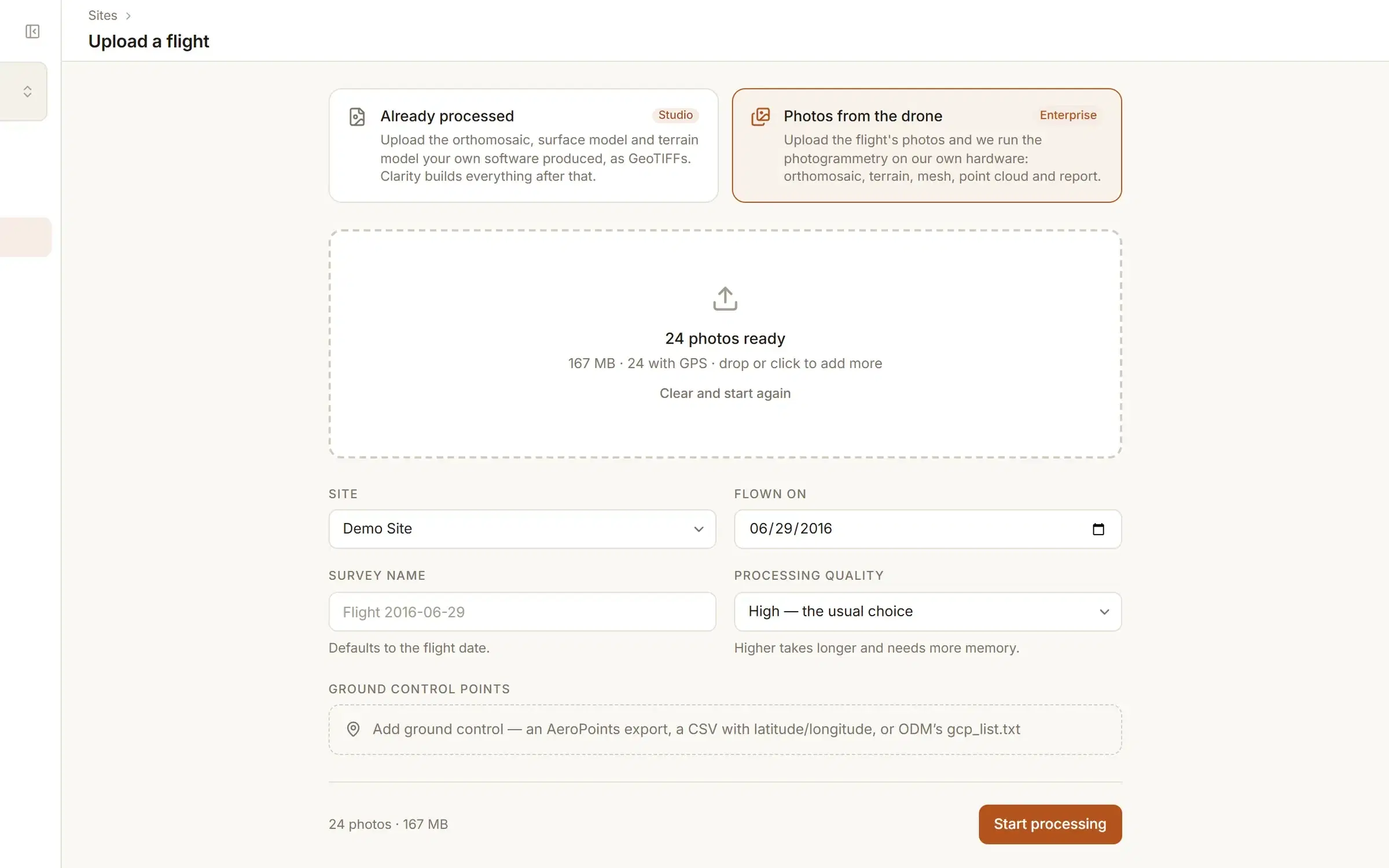
Checked before a single photo is sent.
A flight is gigabytes of photos. The things a browser can check are checked there, before the upload and not after it.
Positions
The GPS position is read out of each JPEG as it is added, and the page shows how many photos carry one. If none do, the flight does not start until something can place it: the flight log, ground control tied to the photos, or geotagged copies. Positions are read from JPEGs only, so a flight of PNG or TIFF files needs the log or the ground control.
Ground control
The file is read as you add it: how many points, which coordinate system, which heights. Ground control only constrains the model when its points are marked in the photos, and it takes at least three such observations. Surveyed positions on their own are kept as reference points, and you are told which you have.
Flight log
The log's GPS track is compared with the times the photos were taken, and the page says how many photos it covers. A log recorded on a different flight cannot stand in for missing positions.
Cost
The credits the flight will use, and what the organisation will have left afterwards, are shown before the upload. A flight the balance cannot cover does not start.
Then the photos go up. Keep the tab open until they have all arrived: the flight joins the queue only once every photo is there. If the connection drops, Try again carries on from the photos already sent. Close the tab and the upload starts from the beginning.
Then it runs without you.
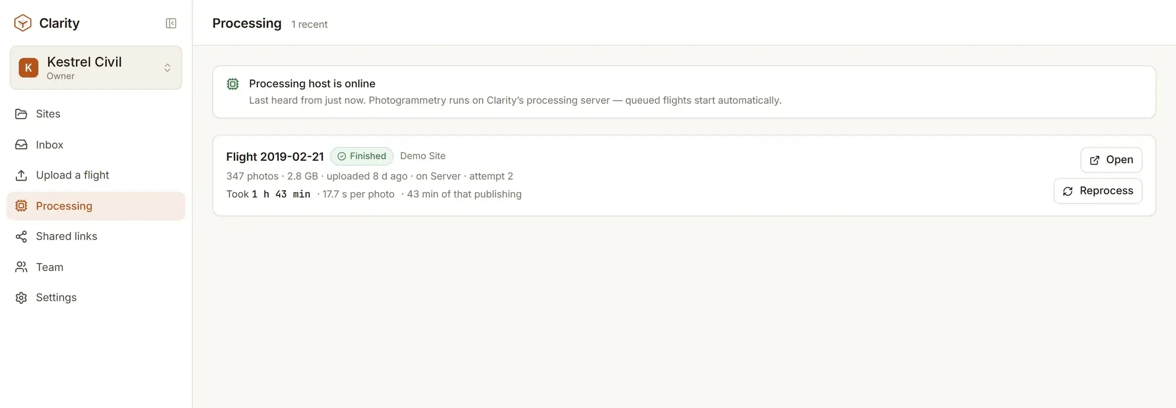
Flights start by themselves, in the order they arrive. Close the page and come back; processing carries on without it.
- Each flight shows its stage on the Processing page: queued, fetching the photos, building the model, publishing the layers. A percentage and a running clock go with it.
- Some steps, texturing among them, report nothing until they finish. The page says when a bar that has stopped moving is still a flight being worked on.
- A flight waiting in the queue can be held until you release it. A flight can be cancelled before it finishes: processing stops and nothing new is published.
- A flight that fails, or that you cancel, gets its credits back. Its photos are already stored, so Try again puts it back in the queue without another upload.
- An email when the flight lands, with a link straight to it.
We do not promise a turnaround time. How long a flight takes depends on the number of photos, the quality you picked and the queue ahead of it. Once your organisation has finished flights behind it, a new one shows roughly how long that many photos usually take.
What comes back.
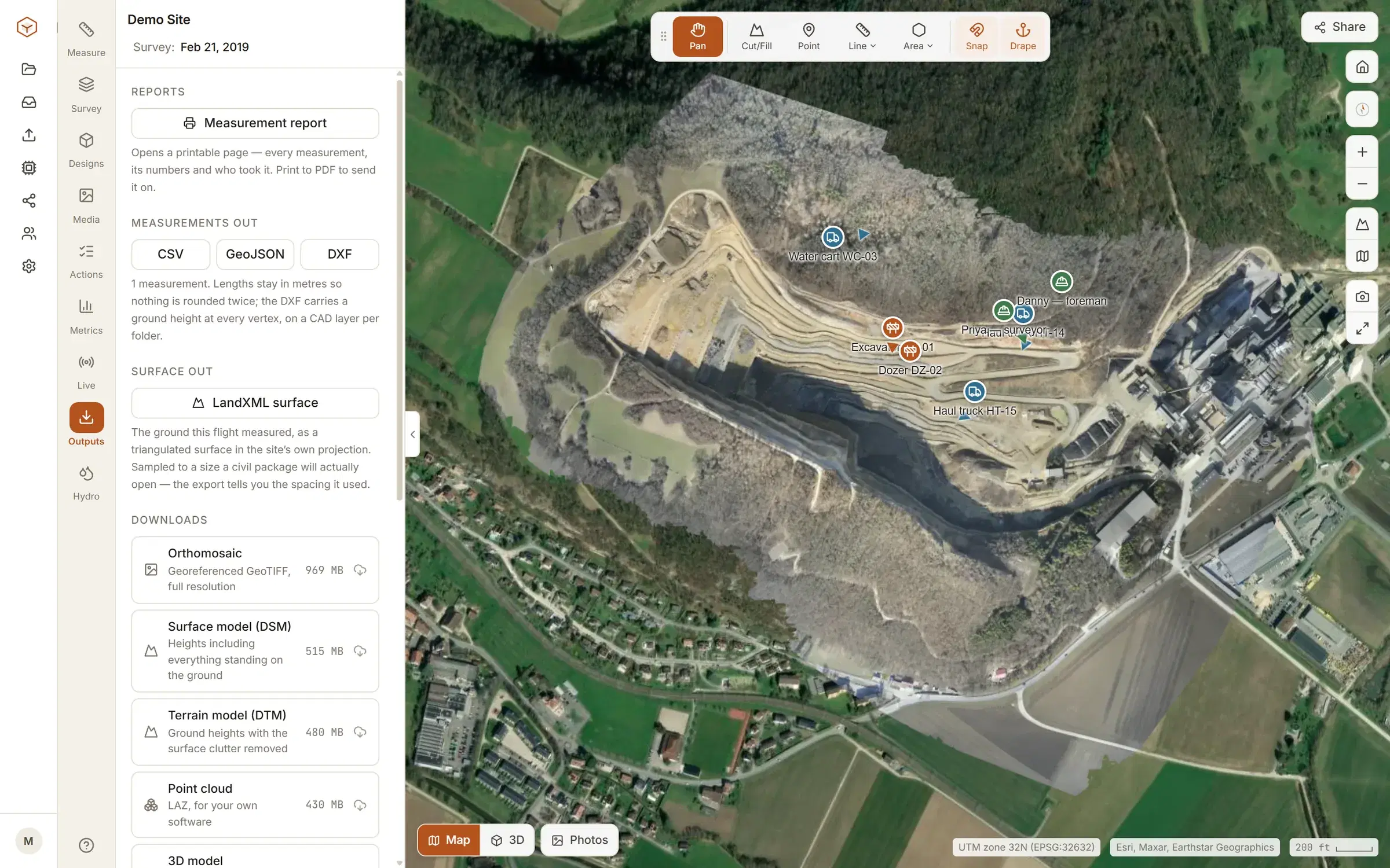
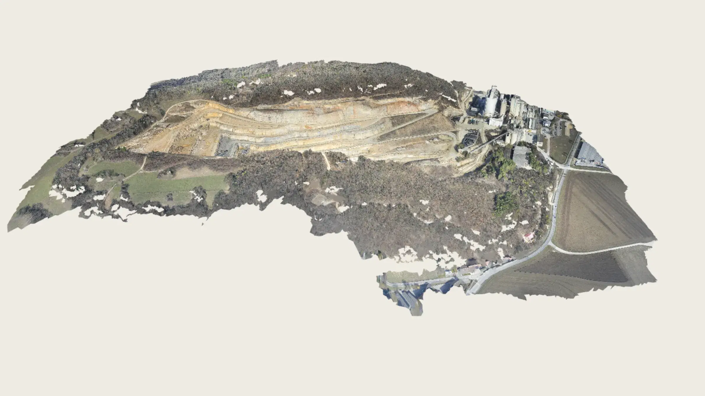
The survey opens in the viewer with the orthomosaic laid over its terrain model, and the files behind it are yours to download.
- Orthomosaic
- GeoTIFF, full resolution
- Surface model (DSM)
- GeoTIFF
- Terrain model (DTM)
- GeoTIFF
- Point cloud
- LAZ
- 3D model
- Textured mesh, glTF binary
- Processing report
- Camera positions
- GeoJSON
- Surface for CAD
- LandXML
Each file appears in the Outputs tab once it has been published for the flight, beside the flight’s ground resolution and coordinate system. A finished flight is locked: photos are not added to it later, and new photos are a new flight on the same site.
In the viewer the terrain can be coloured by relief, slope, aspect or height and contoured at the interval you pick, and the mesh can be orbited in 3D. Then the survey work starts: stockpile volumes, cut and fill against a design, and every other tool. How the photos become a map, step by step, is in the aerial photogrammetry guide.
Who can send photos, and how it is charged.
Processing from raw photos is part of Enterprise. It is metered in credits that pool across the whole organisation.
One credit covers 100 photos at up to 24 megapixels, so a 1,000-photo flight is ten. Larger photos count for more: a 45 megapixel photo counts as two and a 61 megapixel photo as three, and the largest photo in the flight sets the rate. The flight is charged when it joins the queue. Credits are valid for twelve months from purchase.
Enterprise is priced with us directly, by how often you fly rather than per site or per seat. What each plan includes.
Studio on its own does not process raw photos. It starts from the orthomosaic and terrain models your own software has made, as GeoTIFFs, which makes it an online home for the orthomosaic you have. A Studio organisation that wants a flight processed can add processing credits on its plan page.
Explore is free and cannot upload. Its demo site is a finished survey, so you can judge the result before you send a flight. Its files are listed there too; downloading them is what the paid plans add.
What happens to the photos.
They stay yours. They are kept long enough to run the flight again, and then they are removed.
Your imagery is not used to train models, and it is not sold. How sites and files are kept apart, and the whole path from upload to export.
- Kept for seven days
- Originals are uploaded to your organisation's own storage and kept for seven days after the flight finishes processing, then removed. The finished survey stays for as long as you keep the flight.
- Run again without uploading
- Inside those seven days a flight can be built again from the originals. The current map and layers stay up until the new ones are published, and measurements are kept. After that, running it again means uploading it again.
- The processing copy
- To process a flight, a copy of the photos goes to the machine that runs the photogrammetry. It is deleted from that machine when processing ends, whether the flight finished, failed or was cancelled.
- Kept secure
- Your files are stored privately for your organisation with established cloud providers in North America, and only people you allow can see them.
Open a finished survey before you send a flight.
The demo quarry is in every new account, free. Processing your own photos is Enterprise, or credits on Studio. See pricing.